Village of Athens zoning map, an updated zoning map was developed to reflect the latest land use regulations, community planning objectives, and growth patterns. The map serves as a critical tool for local government, and residents, ensuring clarity around zoning districts, permitted land uses, and development guidelines. This enhanced zoning map promotes better decision-making, more efficient land management, and clearer communication with stakeholders.
Great Pinery Heritage Waterway
The Great Pinery Heritage Waterway™ is a navigable water trail located in Northcentral Wisconsin. Situated on the Wisconsin River and its tributaries, the trail spans several counties and is 108 miles long.
The Great Pinery Heritage Waterway winds through scenic forests, urban landscapes and historic sites, inviting paddlers to immerse themselves in the natural beauty of the Great Pinery, learn about the native inhabitants and European settlers who once navigated these waters, and enjoy local attractions, food and happenings.
NCWRPC mapped the trail and features along the route.
Oneida County Online Mapping Records
Site created by NCWRPC to search indexed survey records and other online documents.
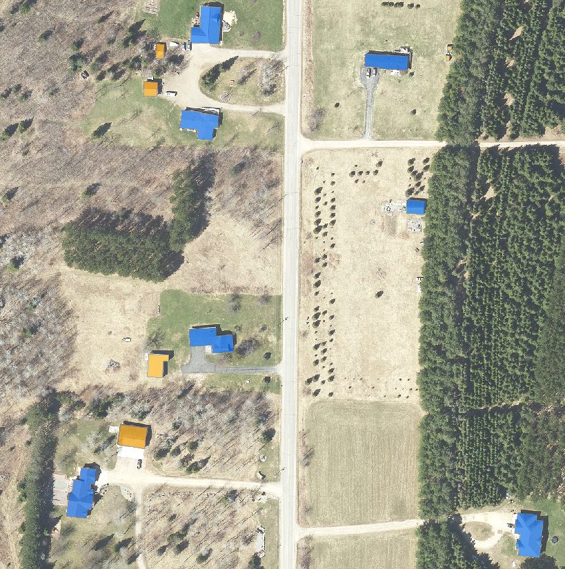
Forest County Building Mapping
Delineation of building outlines from orthoimagery. Map all buildings from 2020 imagery to be used in county 911 system. Projected project completion June 2022.
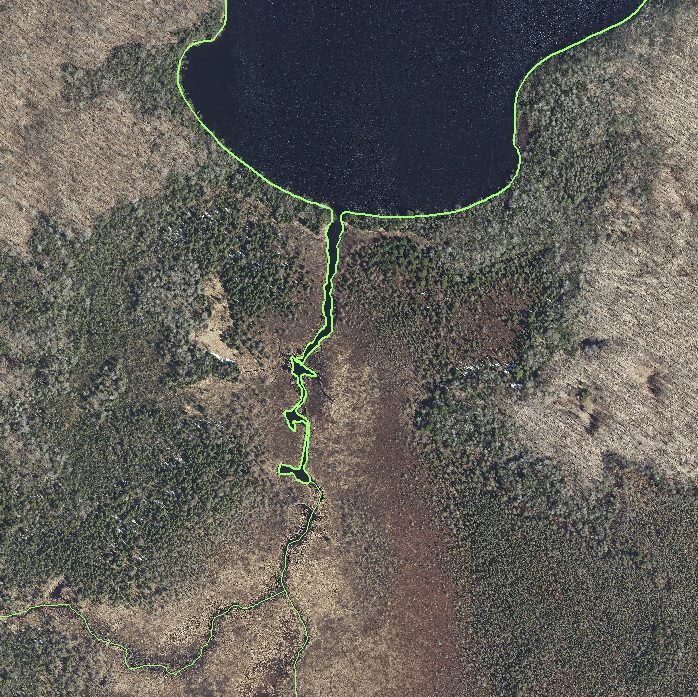
Forest County Hydro Mapping
Enhance the Forest County GIS hydrology layer through the utilization of LiDAR and imagery data by the GIS team, ensuring the accurate update of stream and water body delineations. Anticipated project completion by June 2022.
Wisconsin Regional Orthoimagery Consortium (WROC)
The Wisconsin Regional Orthoimagery Consortium (WROC) is a multi-entity group. The goal of the consortium is to build and sustain a multi-participant program to acquire digital orthoimagery and elevation data throughout Wisconsin. The WROC approach brings a number of potential benefits to participants including cost savings, specifications and standards support, customized datasets, data sharing between members and partners, and procurement support.
Next round
The next round of WROC is underway. North Central Wisconsin Regional Planning Commission (NCWRPC) will once again coordinate and lead the Consortium. In 2021, the RPC extended its agreement with Ayres Associates to facilitate the Consortium and provide geospatial services to its members and partners.
There will be options for participation in 2023, 2024, and 2025. A number of member counties will be going to a 3-year cycle starting in 2023. Another group of counties will fly in 2024.The largest group will participate again in 2025, keeping the consistency of the 5-year cycle. Member counties flying in 2023, 2024, and 2025 will be eligible for partner funding.
The aerial mapping services provided under WROC will continue to evolve to meet the needs of local government members and partner organizations. This will be achieved through a coordinated, county-by-county approach over the next three years, with participation peaking in 2025. Program representatives will work with all private, federal, and state partners to build the program into regional datasets. WROC has a stated goal of achieving statewide coverage by the end of 2025.
WROC representatives will be hosting meetings across the state to discuss the consortium approach and participation options for 2023-25. If you are interested in meeting, please contact program managers Andy Faust or Zach Nienow
Wood County
Wood County is a county located in central Wisconsin. As of the 2020 census, the population was 74,207. The county seat is Wisconsin Rapids. Wood County was created in 1856 and is named after Joseph Wood, who was a Wisconsin State Assemblyman. The county is known for its many lakes, rivers and outdoor recreational opportunities, including the Wood County Parks, the Wisconsin River and the Ice Age Trail. The county is home to the city of Wisconsin Rapids, which is the county’s largest city and the regional center for commerce, industry, healthcare, and education. The county also has several small towns and communities, including Marshfield, Nekoosa, and Port Edwards. The county has a diverse economy, with healthcare, manufacturing and service industries being the main drivers. The county is also known for its paper mills, which have been a staple industry in the area for many years.
Vilas County
Vilas County is a county located in northern Wisconsin. As of the 2020 census, the population was 23,047. The county seat is Eagle River. Vilas County was created in 1893 and is named after William Freeman Vilas, who was a U.S. Senator from Wisconsin. The county is known for its many lakes, forests, and outdoor recreational opportunities, including the Vilas County Parks, the Eagle River Chain of Lakes and the Nicolet National Forest. The county is home to the city of Eagle River, which is the county’s largest city and the regional center for tourism and recreation. The county also has several small towns and communities, including St Germain, Conover, and Boulder Junction. The county has a strong tourism industry, with many visitors coming to the county for fishing, hunting, boating and snowmobiling.
Portage County
Portage County is a county located in central Wisconsin. As of the 2020 census, the population was 70,377. The county seat is Stevens Point. Portage County was created in 1839 and is named after the Fox-Wisconsin Waterway, a historic portage route used by Native Americans and European settlers. The county is known for its many lakes, rivers, and outdoor recreational opportunities, including the Tomorrow River State Trail, the Wisconsin River and the Ice Age Trail. The county is home to the city of Stevens Point, which is the county’s largest city and the regional center for commerce, industry, healthcare, and education. The county also has several small towns and communities, including Plover, Rosholt, and Amherst. The county has a diverse economy, with healthcare, manufacturing, and service industries being the main drivers.
Oneida County
Oneida County is a county located in northern Wisconsin. As of the 2020 census, the population was 37,845. The county seat is Rhinelander. Oneida County was created in 1887 and is named after the Oneida Nation, which is a tribe of the Iroquois Confederacy. The county is known for its many lakes, forests, and outdoor recreational opportunities, including the Oneida County Forest, the Wisconsin River and the Nicolet National Forest. The county is home to the city of Rhinelander, which is the county’s largest city and the regional center for commerce, industry, healthcare, and education. The county also has several small towns and communities, including Three Lakes, Minocqua, and Hazelhurst. The county has a diverse economy, with tourism, manufacturing, and service industries being the main drivers.